AutoCAD Map 3D 2013正式版发布
2012-04-01 11:22
387 查看
AutoCAD Map 3D 2013版已经正式发布。困扰n多人的DWG到AIMS(或者说MapGuide)的问题在这个版本中得到了解决,在Map 3D中可以直接发布DWG文件到AIMS,不经过任何格式转换,同时还能保持原有的线型样式等可视化特征。后续我会写文章详细介绍。下面是Autodesk网站上关于Map 3D 2013最新特性的介绍,先睹为快吧。
试用版下载地址:http://usa.autodesk.com/autocad-map-3d/trial/
ADN用户可以登录ADN网站(http://adn.autodesk.com) 来下载正式版,并获取序列号。
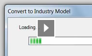
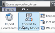
Convert GIS and CAD Data to Intelligent Industry Models
With AutoCAD® Map 3D 2013 software, GIS professionals, planners, and civil engineers can more easily create and manage intelligent industry models by converting GIS and CAD data. Users can populate a new industry model from FDO data sources or DWG™ files and map feature classes and attributes. Then, convert the data to a model and save the database as a DWG/DWT file for use in future projects.

View Now Video (1:57)
View Larger
View Now Video (1:14) Access to Industry Models in More Formats
GIS professionals, planners, and civil engineers can access industry models in Microsoft SQL Server with AutoCAD Map 3D 2013. With the enhanced FDO provider, users can work with enterprise industry models on SQL Server as they do Oracle® systems.
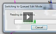
View Now Video (1:00) Check Out Enterprise Industry Model Data
AutoCAD Map 3D provides GIS professionals, planners, and civil engineers the ability to check out enterprise model data for use in the field and use industry models in queued edit mode. With offline editing and synchronization, users can go offline with industry model data, work offline, and then come back and merge the data. Desktop to Web to Autodesk Cloud
The AutoCAD® WS web and mobile application for AutoCAD® software enables you to view, edit, and share DWG drawings using Autodesk® Cloud. Work virtually anywhere and with almost anyone. Store AutoCAD drawings and project files in an easy-to-access online workspace. View and edit your designs online or on your mobile device. Share and collaborate easily with others. There’s no software required, and it’s free with Autodesk® Subscription*.
View Now Video (1:22) Configure & Utilize Linear Referencing Systems with Industry Models
AutoCAD Map 3D 2013 provides the framework for developing a Linear Referencing System (LRS) application, such as rail or transportation module, using the Autodesk Infrastructure Administrator. Within the new industry model, define the LRS based on existing assets and line segments. Then, include a prefix for your LRS, helping to specify the feature classes in your system. After new custom feature classes have been defined, configure the LRS by adding asset relationships. Then, open and manage a road or railway LRS template using AutoCAD Map 3D. Data Exchange with Civil 3D and AutoCAD Utility Design
AutoCAD Map 3D 2013 helps you utilize the same data in different products. Share data more easily between AutoCAD Map 3D, Autodesk® Infrastructure Modeler, AutoCAD® Civil 3D®, and AutoCAD® Utility Design software. Sharing industry data models helps teams to work more efficiently and effectively on projects.
View Larger
View Now Video (0:40)
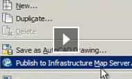
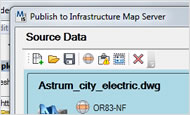
View Now Video (1:31) Publish Native DWG to Autodesk Infrastructure Map Server
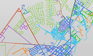
Publish a single DWG directly to Autodesk Infrastructure Map Server using AutoCAD Map 3D 2013, or publish multiple drawing files into a single map definition by using Infrastructure Studio 2013. When publishing to Autodesk® Infrastructure Map Server software, FDO layers and AutoCAD layers—together with data filters—are published together, providing 100 percent visual and data fidelity of DWG files without conversion.
View Larger
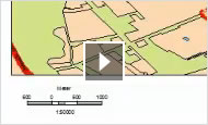
View Larger Dynamic Legends, North Arrows & Scale Bars
Improve public view documents, such as maps and exhibits, with north arrows, scale bars, dynamic legends, and more viewports within the exhibit documentation.
View Now Video (1:37)
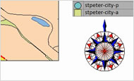
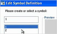
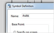
View Larger Creating & Editing Symbols
AutoCAD Map 3D 2013 offers a symbol-authoring tool that enables users to take common symbols used widely in the public domain and make them usable in their mapping environment. Users can also create and edit symbols specific to organizational requirements.
View Larger
View Larger
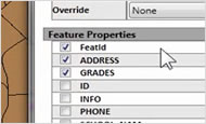
View Larger Dynamic Tooltips & Links
AutoCAD Map 3D 2013 includes the ability to roll over a feature and display properties such as tooltips and links.
试用版下载地址:http://usa.autodesk.com/autocad-map-3d/trial/
ADN用户可以登录ADN网站(http://adn.autodesk.com) 来下载正式版,并获取序列号。
Convert GIS and CAD Data to Intelligent Industry Models
With AutoCAD® Map 3D 2013 software, GIS professionals, planners, and civil engineers can more easily create and manage intelligent industry models by converting GIS and CAD data. Users can populate a new industry model from FDO data sources or DWG™ files and map feature classes and attributes. Then, convert the data to a model and save the database as a DWG/DWT file for use in future projects.
View Now Video (1:57)
View Larger
View Now Video (1:14) Access to Industry Models in More Formats
GIS professionals, planners, and civil engineers can access industry models in Microsoft SQL Server with AutoCAD Map 3D 2013. With the enhanced FDO provider, users can work with enterprise industry models on SQL Server as they do Oracle® systems.
View Now Video (1:00) Check Out Enterprise Industry Model Data
AutoCAD Map 3D provides GIS professionals, planners, and civil engineers the ability to check out enterprise model data for use in the field and use industry models in queued edit mode. With offline editing and synchronization, users can go offline with industry model data, work offline, and then come back and merge the data. Desktop to Web to Autodesk Cloud
The AutoCAD® WS web and mobile application for AutoCAD® software enables you to view, edit, and share DWG drawings using Autodesk® Cloud. Work virtually anywhere and with almost anyone. Store AutoCAD drawings and project files in an easy-to-access online workspace. View and edit your designs online or on your mobile device. Share and collaborate easily with others. There’s no software required, and it’s free with Autodesk® Subscription*.
View Now Video (1:22) Configure & Utilize Linear Referencing Systems with Industry Models
AutoCAD Map 3D 2013 provides the framework for developing a Linear Referencing System (LRS) application, such as rail or transportation module, using the Autodesk Infrastructure Administrator. Within the new industry model, define the LRS based on existing assets and line segments. Then, include a prefix for your LRS, helping to specify the feature classes in your system. After new custom feature classes have been defined, configure the LRS by adding asset relationships. Then, open and manage a road or railway LRS template using AutoCAD Map 3D. Data Exchange with Civil 3D and AutoCAD Utility Design
AutoCAD Map 3D 2013 helps you utilize the same data in different products. Share data more easily between AutoCAD Map 3D, Autodesk® Infrastructure Modeler, AutoCAD® Civil 3D®, and AutoCAD® Utility Design software. Sharing industry data models helps teams to work more efficiently and effectively on projects.
View Larger
View Now Video (0:40)
View Now Video (1:31) Publish Native DWG to Autodesk Infrastructure Map Server
Publish a single DWG directly to Autodesk Infrastructure Map Server using AutoCAD Map 3D 2013, or publish multiple drawing files into a single map definition by using Infrastructure Studio 2013. When publishing to Autodesk® Infrastructure Map Server software, FDO layers and AutoCAD layers—together with data filters—are published together, providing 100 percent visual and data fidelity of DWG files without conversion.
View Larger
View Larger Dynamic Legends, North Arrows & Scale Bars
Improve public view documents, such as maps and exhibits, with north arrows, scale bars, dynamic legends, and more viewports within the exhibit documentation.
View Now Video (1:37)
View Larger Creating & Editing Symbols
AutoCAD Map 3D 2013 offers a symbol-authoring tool that enables users to take common symbols used widely in the public domain and make them usable in their mapping environment. Users can also create and edit symbols specific to organizational requirements.
View Larger
View Larger
View Larger Dynamic Tooltips & Links
AutoCAD Map 3D 2013 includes the ability to roll over a feature and display properties such as tooltips and links.

相关文章推荐
- AutoCAD Map 3D 2013新功能视频中文版
- AutoCAD 2013 .net插件创建向导现在支持Map 3D,Civil 3D,AutoCAD Architecture 和AutoCAD MEP
- AutoCAD Map 3D 2011 发布
- Map 3D 2013 新功能和新API WebCast视频下载
- AutoCAD Map 3D 2010 Update 2 – released!
- AutoCAD 2011、Map 3D 2011, Civil 3D 2011命令行中不能输入中文的修复补丁
- 无需格式转换直接发布DWG图纸到Autodesk Infrastructure Map Server(AIMS) 2013
- AutoCAD Map 3D 2011 Update 1 – released!
- [书友交流] <Autodesk 地理信息系统解决方案--FDO、MapGuide、AutoCAD Map 3D二次开发指南>读书交流贴
- Failed to add FS to collection at ResourceService.SetResource in Map 3D 2013
- 6 月23号周三AutoCAD Map 3D 2011 API 网络培训录像下载
- Map 3D 2013中的AcMapMap.GroupModified 和AcMapMap.LayerModified 事件的参数变化
- AutoCAD Map 3D 2014的开发文档哪儿去了?
- 直接发布DWG到MapGuide/AIMS 2013
- [Map 3D开发实战系列] Map Resource Explorer 之三-- 添加AutoCAD风格的Palette界面
- 6月23号周三AutoCAD Map 3D 2011 API 网络培训参加方式
- AutoCAD.net/Map 3D/AIMS/MapGuide/Civil 3D二次开发学习指南
- 下载AutoCAD Map 3D 2011免费试用版
- Export DWG with ObjectData to ESRI shape file using AutoCAD Map 3D API