FileGDB API for linux 学习系列之四,XML Schema of Geodatabase
2011-03-03 14:45
453 查看
从很早以前(至少从ArcGIS9.2包括9.2)ESRI的桌面产品就提供了将空间数据导成XML文件的功能,如下图,
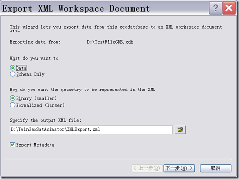
可以选择只将数据库的schema的结构导出,也可以选择将数据也一并导出。到现在的FileGDB API继续沿用这一架构。在FileGDB API中提供了很多
操作Schema内容的函数,如:
操作Domain的函数:
CreateDomain(const std::string &domainDef) //创建域
AlterDomain(const std::string &domainDef) //改变域
DeleteDomain(const std::string &domainDef) //删除域
操作表的函数:
AddField(std::string &fieldDef) //添加字段
AlterField(std::string &fieldDef)//改变字段
DeleteField(std::string &fieldDef)//删除字段
操作子类的函数:
CreateSubtype(std::string &subtypeDef) //创建子类
AlterSubtype(std::string &subtypeDef)//改变子类
DeleteSubtype(std::string &subtypeDef)//删除子类
等等,所有的牵扯到Schema中对象的定义,修改,删除等函数的参数,都是XML格式,当然这些XML格式并不能随便写,必须得按照ESRI的规范
进行书写,具体规范在FileGDB API的doc文件中的XML_Schema_of_Geodatabase-3.pdf中有详细的介绍。以下是常用的几种对象的定义规范:
1. 字段的定义
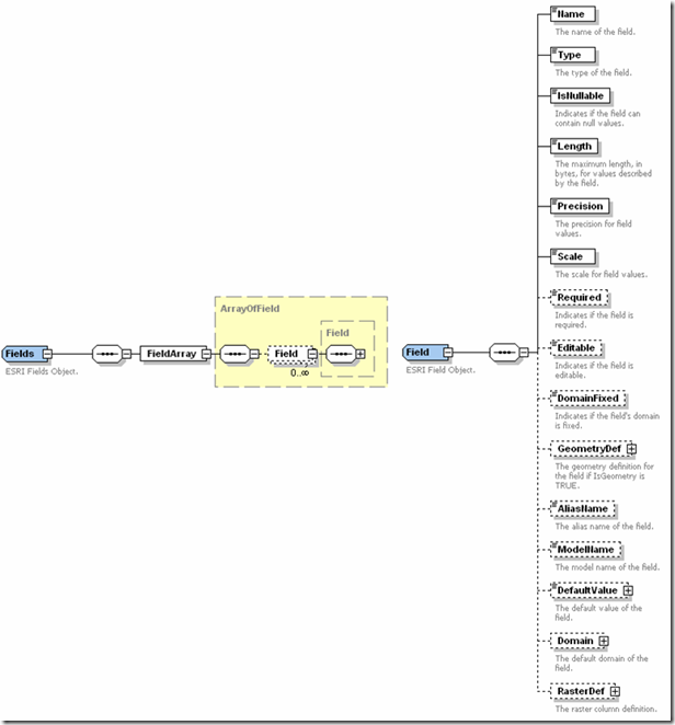
以下是XML表示的Field例子:
esriFieldTypeSmallInteger
esriFieldTypeInteger
esriFieldTypeSingle
esriFieldTypeDouble
esriFieldTypeString
esriFieldTypeDate
esriFieldTypeOID
esriFieldTypeGeometry
esriFieldTypeBlob
esriFieldTypeRaster
esriFieldTypeGUID
esriFieldTypeGlobalID
esriFieldTypeXML
3. 索引的定义

XML例子表示:
SubType的XML的结构图:
XML的例子:
先举着这些例子吧,居然别的类型,可以查看pdf文件。

可以选择只将数据库的schema的结构导出,也可以选择将数据也一并导出。到现在的FileGDB API继续沿用这一架构。在FileGDB API中提供了很多
操作Schema内容的函数,如:
操作Domain的函数:
CreateDomain(const std::string &domainDef) //创建域
AlterDomain(const std::string &domainDef) //改变域
DeleteDomain(const std::string &domainDef) //删除域
操作表的函数:
AddField(std::string &fieldDef) //添加字段
AlterField(std::string &fieldDef)//改变字段
DeleteField(std::string &fieldDef)//删除字段
操作子类的函数:
CreateSubtype(std::string &subtypeDef) //创建子类
AlterSubtype(std::string &subtypeDef)//改变子类
DeleteSubtype(std::string &subtypeDef)//删除子类
等等,所有的牵扯到Schema中对象的定义,修改,删除等函数的参数,都是XML格式,当然这些XML格式并不能随便写,必须得按照ESRI的规范
进行书写,具体规范在FileGDB API的doc文件中的XML_Schema_of_Geodatabase-3.pdf中有详细的介绍。以下是常用的几种对象的定义规范:
1. 字段的定义

以下是XML表示的Field例子:
<Field xmlns:xsi='http://www.w3.org/2001/XMLSchema-instance' xmlns:xs='http://www.w3.org/2001/XMLSchema'
xmlns:esri='http://www.esri.com/schemas/ArcGIS/10.1' xsi:type='esri:Field'>
<Name>nightName>
<Type>esriFieldTypeStringType>
<IsNullable>trueIsNullable>
<Length>4Length>
<Precision>0Precision>
<Scale>0Scale>
<AliasName>dayAliasName>
<ModelName>nightModelName>
<DefaultValue xsi:type="xs:string">afternoonDefaultValue>
Field>
其中Type元素定义了字段的类型,FileGDB API一共提供了13种数据类型,分别是
esriFieldTypeSmallInteger
esriFieldTypeInteger
esriFieldTypeSingle
esriFieldTypeDouble
esriFieldTypeString
esriFieldTypeDate
esriFieldTypeOID
esriFieldTypeGeometry
esriFieldTypeBlob
esriFieldTypeRaster
esriFieldTypeGUID
esriFieldTypeGlobalID
esriFieldTypeXML
2. 表的定义
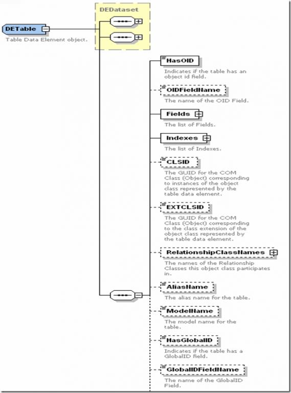

XML例子如下:
xml version="1.0" encoding="UTF-8"?>
<esri:DataElement xmlns:esri='http://www.esri.com/schemas/ArcGIS/10.1'
xmlns:xsi='http://www.w3.org/2001/XMLSchema-instance' xmlns:xs='http://www.w3.org/2001/XMLSchema' xsi:type='esri:DETable'>
<CatalogPath>/StreetInfoCatalogPath>
<Name>StreetInfoName>
<MetadataRetrieved>trueMetadataRetrieved>
<Metadata xsi:type='esri:XmlPropertySet'>
<XmlDoc>
<?xml version="1.0"?>
<metadata xml:lang="en"><Esri><CreaDate>20101215</CreaDate><CreaTime>13025800</CreaTime><ArcGISFormat>1.0</ArcGISFormat><SyncOnce>TRUE</SyncOnce></Esri></metadata>
XmlDoc>
Metadata>
<DatasetType>esriDTTableDatasetType>
<Versioned>falseVersioned>
<CanVersion>falseCanVersion>
<ConfigurationKeyword>ConfigurationKeyword>
<HasOID>trueHasOID>
<OIDFieldName>OBJECTIDOIDFieldName>
<Fields xsi:type='esri:Fields'>
<FieldArray xsi:type='esri:ArrayOfField'>
<Field xsi:type='esri:Field'>
<Name>OBJECTIDName>
<Type>esriFieldTypeOIDType>
<IsNullable>falseIsNullable>
<Length>4Length>
<Precision>0Precision>
<Scale>0Scale>
<Required>trueRequired>
<Editable>falseEditable>
<DomainFixed>trueDomainFixed>
<AliasName>OBJECTIDAliasName>
<ModelName>OBJECTIDModelName>
Field>
<Field xsi:type='esri:Field'>
<Name>NameName>
<Type>esriFieldTypeStringType>
<IsNullable>trueIsNullable>
<Length>50Length>
<Precision>0Precision>
<Scale>0Scale>
<AliasName>NameAliasName>
<ModelName>NameModelName>
<DefaultValue xsi:type='xs:string'>DefaultValue>
Field>
<Field xsi:type='esri:Field'>
<Name>StreetTypeName>
<Type>esriFieldTypeIntegerType>
<IsNullable>trueIsNullable>
<Length>4Length>
<Precision>0Precision>
<Scale>0Scale>
<AliasName>StreetTypeAliasName>
<ModelName>StreetTypeModelName>
<DefaultValue xsi:type='xs:double'>1DefaultValue>
Field>
<Field xsi:type='esri:Field'>
<Name>WidthName>
<Type>esriFieldTypeDoubleType>
<IsNullable>trueIsNullable>
<Length>8Length>
<Precision>0Precision>
<Scale>0Scale>
<AliasName>WidthAliasName>
<ModelName>WidthModelName>
<DefaultValue xsi:type='xs:double'>25.0DefaultValue>
Field>
<Field xsi:type='esri:Field'>
<Name>LastPavedName>
<Type>esriFieldTypeDateType>
<IsNullable>trueIsNullable>
<Length>8Length>
<Precision>0Precision>
<Scale>0Scale>
<AliasName>LastPavedAliasName>
<ModelName>LastPavedModelName>
<DefaultValue xsi:type='xs:dateTime'>2000-01-01T00:00:00DefaultValue>
Field>
FieldArray>
Fields>
<Indexes xsi:type='esri:Indexes'>
<IndexArray xsi:type='esri:ArrayOfIndex'>
<Index xsi:type='esri:Index'>
<Name>FDO_OBJECTIDName>
<IsUnique>trueIsUnique>
<IsAscending>trueIsAscending>
<Fields xsi:type='esri:Fields'>
<FieldArray xsi:type='esri:ArrayOfField'>
<Field xsi:type='esri:Field'>
<Name>OBJECTIDName>
<Type>esriFieldTypeOIDType>
<IsNullable>falseIsNullable>
<Length>4Length>
<Precision>0Precision>
<Scale>0Scale>
<Required>trueRequired>
<Editable>falseEditable>
<DomainFixed>trueDomainFixed>
<AliasName>OBJECTIDAliasName>
<ModelName>OBJECTIDModelName>
Field>
FieldArray>
Fields>
Index>
IndexArray>
Indexes>
<CLSID>{7A566981-C114-11D2-8A28-006097AFF44E}CLSID>
<EXTCLSID>EXTCLSID>
<RelationshipClassNames xsi:type='esri:Names'>RelationshipClassNames>
<AliasName>TestTableAliasName>
<ModelName>ModelName>
<HasGlobalID>falseHasGlobalID>
<GlobalIDFieldName>GlobalIDFieldName>
<RasterFieldName>RasterFieldName>
<ExtensionProperties xsi:type='esri:PropertySet'>
<PropertyArray xsi:type='esri:ArrayOfPropertySetProperty'>PropertyArray>
ExtensionProperties>
<ControllerMemberships xsi:type='esri:ArrayOfControllerMembership'>ControllerMemberships>
esri:DataElement>
3. 索引的定义

XML例子表示:
<esri:Index xsi:type='esri:Index' xmlns:xsi='http://www.w3.org/2001/XMLSchema-instance'
xmlns:xs='http://www.w3.org/2001/XMLSchema' xmlns:esri='http://www.esri.com/schemas/ArcGIS/10.1'>
<Name>StreetTypeIdxName>
<IsUnique>falseIsUnique>
<IsAscending>trueIsAscending>
<Fields xsi:type='esri:Fields'>
<FieldArray xsi:type='esri:ArrayOfField'>
<Field xsi:type='esri:Field'>
<Name>StreetTypeName>
<Type>esriFieldTypeSmallIntegerType>
<IsNullable>falseIsNullable>
<Length>2Length>
<Precision>0Precision>
<Scale>0Scale>
<Required>trueRequired>
<Editable>falseEditable>
<DomainFixed>trueDomainFixed>
<AliasName>StreetTypeAliasName>
<ModelName>StreetTypeModelName>
Field>
FieldArray>
Fields>
esri:Index>
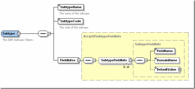
SubType的XML的结构图:

XML的例子:
<esri:Subtype xmlns:xsi="http://www.w3.org/2001/XMLSchema-instance" xmlns:xs=http://www.w3.org/2001/XMLSchema
xmlns:esri="http://www.esri.com/schemas/ArcGIS/10.1" xsi:type="esri:Subtype">
<SubtypeName>subtype threeSubtypeName>
<SubtypeCode>99SubtypeCode>
<FieldInfos xsi:type="esri:ArrayOfSubtypeFieldInfo">
<SubtypeFieldInfo xsi:type="esri:SubtypeFieldInfo">
<FieldName>percentCompleteFieldName>
<DomainName>sampleRangeDomainDomainName>
<DefaultValue xsi:type="xs:double">56DefaultValue>
SubtypeFieldInfo>
FieldInfos>
esri:Subtype>
先举着这些例子吧,居然别的类型,可以查看pdf文件。

相关文章推荐
- FileGDB API for linux 学习系列之二,编译Display例子程序
- FileGDB API for linux学习系列之三,检索目录树
- FileGDB API for linux 学习系列之一,编译例子程序
- FileGDB API for linux 学习系列之六,对象的创建
- FileGDB API for linux学习之八,空间数据解析库
- FileGDB API for linux 学习之七,数据的查询
- File GeoDatabase API学习
- arcgis for android: file:/mnt/sdcard/xxx.geodatabase does not exist.
- Issue 71 - pymssql - Undefined symbols on Mac, CentOS, Redhat with pre-compiled build - A fast MS SQL Server client library for Python directly using C API instead of ODBC. It is Python DB-API 2.0 compliant. Works on Linux, *BSD, Solaris, Mac OS X and Win
- HBase异常:hbase-default.xml file seems to be for and old version of HBase的解决方法
- Sharepoint学习笔记—Site Definition系列-- 4、相对快捷地创建List Definition的Schema.xml文件
- XML错误信息Referenced file contains errors (http://www.springframework.org/schema/beans/spring-beans-4.0.xsd). For more information, right click on the message in the Problems View ...
- 学习J2EE第5天(Simple API for XML)
- File GeoDatabase API简介
- curl出现Deprecated: curl_setopt(): The usage of the @filename API for file uploading is deprecated. Pl
- hbase-default.xml file seems to be for an older version of HBase ,this version is 1.2.0
- hbase启动报错hbase-default.xml file seems to be for and old version of HBase
- No signature of method: static org.gradle.api.java.archives.Manifest.srcFile() is applicable for arg
- 无法启动Hbase hbase-default.xml file seems to be for and old version of HBase
- ErrorException: curl_setopt(): The usage of the @filename API for file uploading is deprecated.