使用OsmSharp处理OpenStreetMap(OSM)数据
2017-05-11 00:00
711 查看
摘要: OsmSharp是一个基于.NET的OpenStreetMap(OSM)库。
Read/Write OSM-XML.
Read/Write OSM-PBF.
Streamed architecture, minimal memory footprint.
Convert a stream of native OSM objects to ‘complete’ OSM objects: Ways with all their actual nodes, Relations with all members instantiated.
Convert OSM objects to geometries.
NetTopologySuite(NTS):一个地理库,可以将其与OsmSharp.Geo一起使用,将OSM数据转换为shapefile或过滤一些数据将其转换为GeoJSON。
ltinero:.NET的路径规划项目。OsmSharp.Routing作为OsmSharp的一部分,现更名为ltinero。
Mapsui:Mapsui是WPF,Xamarin.Android,Xamarin.iOS和UWP应用程序的.NET Map组件。
OsmStreamSource:
XmlOsmStreamSource:读OSM-XML文件
PBFOsmStreamSource:读OSM-PBF文件
OsmStreamTarget:
XmlOsmStreamTarget:写OSM-XML文件
PBFOsmStreamTarget:写OSM-PBF文件
OsmStreamFilter:
OsmStreamFilterDelegate
OsmStreamFilterMerge
OsmStreamFilterNode
OsmStreamFilterProgress
打开"filtered.osm"文件可查看内容,如下:
FilterBox(float left, float top, float right, float bottom,bool completeWays)
FilterSpatial(IPolygon polygon, bool completeWays)
其中,FilterBox()以边框过滤,需设置左、上、右、下的经纬度。FilterSpatial()以ploygon裁剪,保留polygon以内的所有对象,该方法需要引用OsmSharp.Geo。completeWays默认为false,true和false的区别如下图。(红色为设置为true的结果,绿色为设置为false的结果)
示例:
GetPolygonFromGeoJson(string fileName)方法如下,需添加以下引用。
OsmSharp.Db.SQLServer.dll
OsmSharp.Data.SQLServer.dll
①向SQL Server数据库写入OSM数据
实时数据(Snapshot*)和历史数据(History*)的插入方法一致,只是数据表的结构不一样。具体的数据表结构请查看GitHub中的SQL语句。
历史数据(History*)的导入,会因为id重复,而导致导入数据失败!!!
输出的日志:
实时数据的表结构和插入后的数据如下图:
②从SQL Server数据库中读取OSM数据
最好使用NuGet安装,这样会自动添加对应版本的OsmSharp库,否则可能出现某种问题。以下是本文所对应的版本号。
①SQL Server数据库写入OSM数据
OsmSharp.Data.SQLServer.dll并没有对id作限制,因此有重复id的历史数据也可以直接写入数据库中。
history.pbf
下图是历史数据写入的结果,可以看到有重复的id。
②SQL Server数据库读取OSM数据
OsmSharp.Data.SQLServer.dll好像并不能从SQL Server数据库中读取OSM数据。
Itinero.IO.OSM:使用OSM数据
Itinero.IO.Shape:使用shapefile
Itinero.IO.Geo:使用NTS
关键类:RouterDb,Router,Profiles 和 RouterPoint
RouterDb: Manages the data of one routing network. It holds all data in RAM or uses a memory mapping strategy to load data on demand. It holds all the network geometry, meta data and topology.
Router: The main facade for all routing functionality available. It will decide the best algorithm to use based on a combination of what's requested and what data is available in the RouterDb.
Profiles: Definitions of vehicle and their behaviour that can traverse the routing network.
RouterPoint: A location on the routing network to use as a start or endpoint of a route. It's defined by an edge-id and an offset-value uniquely identifying it's location on the network.
通过NuGet安装Itinero和Itinero.IO.OSM,添加引用
加载OSM数据
创建Router
计算
结果
将结果写入GeoJson文件后,添加到geojson.io,计算出的路径如下图。
处理原始数据并写入磁盘。
从磁盘加载预处理的数据并将其用于路径规划。
加载原始数据
将routerDb实例写入到磁盘:
加载routerDb
计算
更过关于路径规划的内容请参考Itinero-GitHub。
更多精彩请关注一氧化二氢
未完待续...
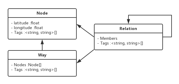
1. OpenStreetMap数据模型
OSM数据有三个基本对象:Node,Way,Relation。更多信息请查看OSM-wiki。2. OsmSharp
OsmSharp可以在直接.NET中使用OSM数据,其主要功能有:Read/Write OSM-XML.
Read/Write OSM-PBF.
Streamed architecture, minimal memory footprint.
Convert a stream of native OSM objects to ‘complete’ OSM objects: Ways with all their actual nodes, Relations with all members instantiated.
Convert OSM objects to geometries.
3. 相关项目
OsmSharp做过与地图相关的很多事情:路径规划、数据处理、渲染矢量数据。下面是OsmSharp与.NET平台的协作项目:NetTopologySuite(NTS):一个地理库,可以将其与OsmSharp.Geo一起使用,将OSM数据转换为shapefile或过滤一些数据将其转换为GeoJSON。
ltinero:.NET的路径规划项目。OsmSharp.Routing作为OsmSharp的一部分,现更名为ltinero。
Mapsui:Mapsui是WPF,Xamarin.Android,Xamarin.iOS和UWP应用程序的.NET Map组件。
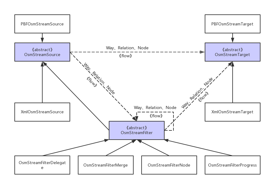
4. 流模型(Streaming Model)
OsmSharp使用流模型处理OSM数据。所有流模型都实现了泛型IEnumerable<T>接口,这就意味着可以使用LINQ查询处理。OsmStreamSource:
XmlOsmStreamSource:读OSM-XML文件
PBFOsmStreamSource:读OSM-PBF文件
OsmStreamTarget:
XmlOsmStreamTarget:写OSM-XML文件
PBFOsmStreamTarget:写OSM-PBF文件
OsmStreamFilter:
OsmStreamFilterDelegate
OsmStreamFilterMerge
OsmStreamFilterNode
OsmStreamFilterProgress
4.1 读OSM-PBF文件
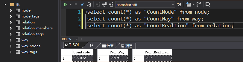
luxembourg-latest.osm.pbf// 读取"luxembourg-latest.osm.pbf"的node、way、relation个数
// 创建StreamSource
var source = new PBFOsmStreamSource(File.OpenRead("luxembourg-latest.osm.pbf"));
int nodes = 0, ways = 0, relations = 0;
foreach (var osmGe
7fe0
o in source)
{
if (osmGeo.Type == OsmGeoType.Node)
{
nodes++;
}
if (osmGeo.Type == OsmGeoType.Way)
{
ways++;
}
if (osmGeo.Type == OsmGeoType.Relation)
{
relations++;
}
}
Console.WriteLine("There are {0} nodes, {1} ways, {2} relations.", nodes, ways, relations);
// 输出:There are 1721051 nodes, 223718 ways, 2511 relations.4.2 LINQ查询过滤数据
// 创建StreamSource
var source = new PBFOsmStreamSource(File.OpenRead("luxembourg-latest.osm.pbf"));
int nodes = 0, ways = 0, relations = 0;
// 使用LINQ查询用户名为"Stilmant Michael"的数据
var filtered = from osmGeo in source where osmGeo.UserName == "Stilmant Michael" select osmGeo;
foreach (var osmGeo in filtered)
{
if (osmGeo.Type == OsmGeoType.Node)
{
nodes++;
}
if (osmGeo.Type == OsmGeoType.Way)
{
ways++;
}
if (osmGeo.Type == OsmGeoType.Relation)
{
relations++;
}
}
Console.WriteLine("There are {0} nodes, {1} ways, {2} relations are edited by Stilmant Michael.", nodes, ways, relations);
// 输出:There are 762 nodes, 77 ways, 0 relations are edited by Stilmant Michael.
4.3 写入OSM-XML文件
// 创建StreamSource
var source = new PBFOsmStreamSource(File.OpenRead("luxembourg-latest.osm.pbf"));
// 过滤
var filterd = from osmGeo in source where osmGeo.UserName == "Stilmant Michael" select osmGeo;
// 创建StreamTarget
var target = new XmlOsmStreamTarget(File.Open("filtered.osm", FileMode.Create));
// 写入
target.RegisterSource(filterd);
target.Pull();
打开"filtered.osm"文件可查看内容,如下:
<?xml version="1.0" encoding="UTF-8"?>
<osm version="0.6" generator="OsmSharp">
<node id="25922353" lat="49.50871" lon="6.010775" user="Stilmant Michael" uid="26290" visible="true" version="36766" changeset="9218254" timestamp="2011-09-05T14:27:47Z">
<tag k="highway" v="crossing" />
<tag k="crossing" v="uncontrolled" />
</node>
<node id="245921260" lat="49.60019" lon="6.124797" user="Stilmant Michael" uid="26290" visible="true" version="10362" changeset="44411" timestamp="2008-02-05T12:37:48Z" />
<node id="245923096" lat="49.5063" lon="6.013138" user="Stilmant Michael" uid="26290" visible="true" version="10516" changeset="9218254" timestamp="2011-09-05T14:27:46Z">
<tag k="highway" v="crossing" />
<tag k="crossing" v="uncontrolled" />
</node>
<node id="245923278" lat="49.50129" lon="6.014411" user="Stilmant Michael" uid="26290" visible="true" version="10557" changeset="44411" timestamp="2008-02-05T12:57:49Z" />
<node id="245923344" lat="49.49693" lon="6.009622" user="Stilmant Michael" uid="26290" visible="true" version="10571" changeset="44411" timestamp="2008-02-05T12:59:12Z" />
<node id="245923345" lat="49.49725" lon="6.009501" user="Stilmant Michael" uid="26290" visible="true" version="10572" changeset="44411" timestamp="2008-02-05T12:59:12Z" />
<!-- 略 -->
<way id="22921571" user="Stilmant Michael" uid="26290" visible="true" version="1" changeset="87062" timestamp="2008-02-09T16:29:01Z">
<nd ref="246813086" />
<nd ref="246813087" />
<nd ref="246813088" />
<nd ref="246813089" />
<tag k="foot" v="yes" />
<tag k="highway" v="footway" />
<tag k="created_by" v="Potlatch 0.7" />
</way>
<way id="22921581" user="Stilmant Michael" uid="26290" visible="true" version="2" changeset="87062" timestamp="2008-02-09T16:31:20Z">
<nd ref="246813139" />
<nd ref="246813140" />
<nd ref="246813141" />
<nd ref="246813142" />
<nd ref="246813139" />
<tag k="amenity" v="parking" />
<tag k="created_by" v="Potlatch 0.7" />
</way>
<!-- 略 -->
</osm>
5. 常用数据处理
5.1 裁剪
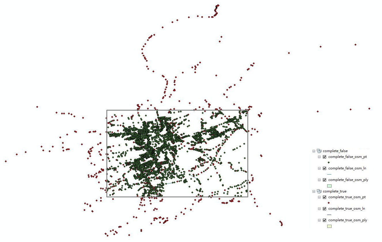
以下两种过滤方法可实现裁剪。FilterBox(float left, float top, float right, float bottom,bool completeWays)
FilterSpatial(IPolygon polygon, bool completeWays)
其中,FilterBox()以边框过滤,需设置左、上、右、下的经纬度。FilterSpatial()以ploygon裁剪,保留polygon以内的所有对象,该方法需要引用OsmSharp.Geo。completeWays默认为false,true和false的区别如下图。(红色为设置为true的结果,绿色为设置为false的结果)
示例:
using (var fileStreamSource = File.OpenRead("luxembourg-latest.osm.pbf"))
{
using (var fileStreamTarget = File.Open("clip.osm", FileMode.Create))
{
// 创建StreamSource
var source = new PBFOsmStreamSource(fileStreamSource);
// 创建StreamTarget
var target = new XmlOsmStreamTarget(fileStreamTarget);
// 1.以边框过滤
//var filtered = source.FilterBox(6.238002777099609f, 49.72076145492323f, 6.272850036621093f, 49.69928180928878f);

// 2.以polygon过滤
var polygon = GetPolygonFromGeoJson("polygon.geojson");
var filtered = source.FilterSpatial(polygon, true);
target.RegisterSource(filtered);
target.Pull();
}
}
GetPolygonFromGeoJson(string fileName)方法如下,需添加以下引用。
using GeoAPI.Geometries;
using NetTopologySuite.Features;
using Newtonsoft.Json;
/// <summary>
/// 从GeoJson中获取Polygon对象
/// </summary>
/// <param name="fileName">文件名</param>
/// <returns></returns>
private static IPolygon GetPolygonFromGeoJson(string fileName)
{
using (var stream = new StreamReader(fileName))
{
var jsonSerializer = new NetTopologySuite.IO.GeoJsonSerializer();
var features = jsonSerializer.Deserialize<FeatureCollection>(new JsonTextReader(stream));
return features.Features[0].Geometry as IPolygon;
}
}
6. 数据库
6.1 SQLServer
OsmSharp-GitHub上有两种方式从/向SQL Server数据库读取/写入OSM数据。OsmSharp.Db.SQLServer.dll
OsmSharp.Data.SQLServer.dll
6.1.1 OsmSharp.Db.SQLServer.dll
使用sqlserver-dataprovider软件包,以SQL Server作为OpenStreetMap数据库。从/向SQL Server数据库读取/写入OSM数据。需添加引用"OsmSharp.Db.SQLServer.dll",最新的GitHub上找不到这个文件,我上传到自己的GitHub了,点击即可下载。①向SQL Server数据库写入OSM数据
实时数据(Snapshot*)和历史数据(History*)的插入方法一致,只是数据表的结构不一样。具体的数据表结构请查看GitHub中的SQL语句。
历史数据(History*)的导入,会因为id重复,而导致导入数据失败!!!
// 连接字符串
string conStr = "Server=*;Database=*;User Id=*;Password=*;MultipleActiveResultSets=true;";
// 启用日志记录
OsmSharp.Logging.Logger.LogAction = (origin, level, message, parameters) =>
{
Console.WriteLine("[{0}-{3}]:{1} - {2}", origin, level, message, DateTime.Now.ToString());
};
// 连接数据库并插入数据
using (var connection = new SqlConnection(conStr))
{
connection.Open();
// 创建数据表
Tools.SnapshotDbCreateAndDetect(connection);
// 删除数据表内容
Tools.SnapshotDbDeleteAll(connection);
using (var stream = File.OpenRead("luxembourg-latest.osm.pbf"))
{
var source = new PBFOsmStreamSource(stream);
var target = new SnapshotDbStreamTarget(conStr, true);
// 插入数据
target.RegisterSource(source);
target.Pull();
}
}
输出的日志:
[Schema.Tools-2017/5/12 13:32:47]:information - Delete all data in snapshot database schema...
[SnapshotDbStreamTarget-2017/5/12 13:32:53]:information - Inserting 1000000 records into node.
[SnapshotDbStreamTarget-2017/5/12 13:33:14]:information - Inserting 80777 records into node_tags.
[SnapshotDbStreamTarget-2017/5/12 13:33:22]:information - Inserting 100000 records into way.
[SnapshotDbStreamTarget-2017/5/12 13:33:23]:information - Inserting 354601 records into way_tags.
[SnapshotDbStreamTarget-2017/5/12 13:33:28]:information - Inserting 1122157 records into way_nodes.
[SnapshotDbStreamTarget-2017/5/12 13:33:43]:information - Inserting 100000 records into way.
[SnapshotDbStreamTarget-2017/5/12 13:33:44]:information - Inserting 256525 records into way_tags.
[SnapshotDbStreamTarget-2017/5/12 13:33:47]:information - Inserting 888866 records into way_nodes.
[SnapshotDbStreamTarget-2017/5/12 13:33:59]:information - Flushing remaining data...
[SnapshotDbStreamTarget-2017/5/12 13:33:59]:information - Inserting 721051 records into node.
[SnapshotDbStreamTarget-2017/5/12 13:34:15]:information - Inserting 55585 records into node_tags.
[SnapshotDbStreamTarget-2017/5/12 13:34:16]:information - Inserting 23718 records into way.
[SnapshotDbStreamTarget-2017/5/12 13:34:16]:information - Inserting 52142 records into way_tags.
[SnapshotDbStreamTarget-2017/5/12 13:34:16]:information - Inserting 282298 records into way_nodes.
[SnapshotDbStreamTarget-2017/5/12 13:34:19]:information - Inserting 2511 records into relation.
[SnapshotDbStreamTarget-2017/5/12 13:34:20]:information - Inserting 14759 records into relation_tags.
[SnapshotDbStreamTarget-2017/5/12 13:34:20]:information - Inserting 146095 records into relation_members.
[SnapshotDbStreamTarget-2017/5/12 13:34:22]:information - Database connection closed.
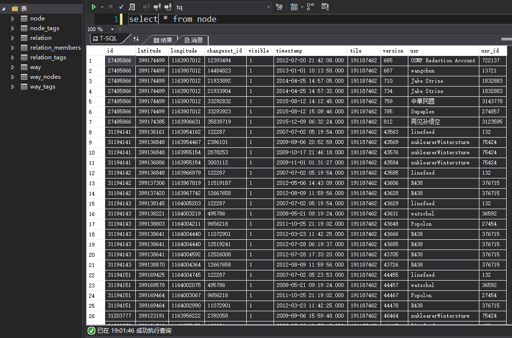
实时数据的表结构和插入后的数据如下图:
②从SQL Server数据库中读取OSM数据
// 连接字符串
string conStr = "Server=*;Database=*;User Id=*;Password=*;MultipleActiveResultSets=true;";
using (var connection = new SqlConnection(conStr))
{
connection.Open();
// 从数据库中读取OSM数据
var source = new SnapshotDbStreamSource(conStr);
int nodes = 0, ways = 0, relations = 0;
foreach (var osmGeo in source)
{
if (osmGeo.Type == OsmGeoType.Node)
{
nodes++;
}
if (osmGeo.Type == OsmGeoType.Way)
{
ways++;
}
if (osmGeo.Type == OsmGeoType.Relation)
{
relations++;
}
}
Console.WriteLine("There are {0} nodes, {1} ways, {2} relations.", nodes, ways, relations);
}
// 输出:There are 1721051 nodes, 223718 ways, 2511 relations.
6.1.2 OsmSharp.Data.SQLServer.dll
使用data-providers软件包,可以下载“OsmSharp.Data.SQLServer.dll”文件,添加引用,也可以用NuGet搜索“OsmSharp.SQLServer”安装。最好使用NuGet安装,这样会自动添加对应版本的OsmSharp库,否则可能出现某种问题。以下是本文所对应的版本号。
<packages>
<package id="OsmSharp" version="4.2.0.723" targetFramework="net452" />
<package id="OsmSharp.SQLServer" version="4.2.0.723" targetFramework="net452" />
</packages>
①SQL Server数据库写入OSM数据
OsmSharp.Data.SQLServer.dll并没有对id作限制,因此有重复id的历史数据也可以直接写入数据库中。
history.pbf
string conStr = "Server=*;Database=*;User Id=*;Password=*;MultipleActiveResultSets=true;";
using (var connection = new SqlConnection(conStr))
{
connection.Open();
// 删除原有数据表
SQLServerSchemaTools.Remove(connection);
// 创建数据表
SQLServerSchemaTools.CreateAndDetect(connection);
// 实时数据
// using (Stream stream = File.OpenRead("luxembourg-latest.osm.pbf"))
// 历史数据
using (Stream stream = File.OpenRead("history.pbf"))
{
var source = new PBFOsmStreamSource(stream);
var target = new SQLServerOsmStreamTarget(connection);
// 插入数据
target.RegisterSource(source);
target.Pull();
}
}
下图是历史数据写入的结果,可以看到有重复的id。
②SQL Server数据库读取OSM数据
OsmSharp.Data.SQLServer.dll好像并不能从SQL Server数据库中读取OSM数据。
7. 路径规划
7.1 Itinero
ltinero:.NET的路径规划项目。Itinero.IO.OSM:使用OSM数据
Itinero.IO.Shape:使用shapefile
Itinero.IO.Geo:使用NTS
关键类:RouterDb,Router,Profiles 和 RouterPoint
RouterDb: Manages the data of one routing network. It holds all data in RAM or uses a memory mapping strategy to load data on demand. It holds all the network geometry, meta data and topology.
Router: The main facade for all routing functionality available. It will decide the best algorithm to use based on a combination of what's requested and what data is available in the RouterDb.
Profiles: Definitions of vehicle and their behaviour that can traverse the routing network.
RouterPoint: A location on the routing network to use as a start or endpoint of a route. It's defined by an edge-id and an offset-value uniquely identifying it's location on the network.
7.2 示例
下面通过一个简单的示例介绍如何使用OSM数据做路径规划。通过NuGet安装Itinero和Itinero.IO.OSM,添加引用
using Itinero;
using Itinero.IO.Osm;
using Itinero.LocalGeo;
using Itinero.Osm.Vehicles;
加载OSM数据
// 加载OSM数据
var routerDb = new RouterDb();
using (var stream = File.OpenRead("beijing.osm.pbf"))
{
routerDb.LoadOsmData(stream, Vehicle.Car);
}
创建Router
var router = new Router(routerDb);
计算
var route = router.Calculate(Vehicle.Car.Fastest(), new Coordinate(39.9225f, 116.3669f), new Coordinate(39.9066f, 116.4053f));

// Vehicle
// public static readonly Profiles.Vehicle Car;
// public static readonly Profiles.Vehicle Pedestrian;
// public static readonly Profiles.Vehicle Bicycle;
// public static readonly Profiles.Vehicle Moped;
// public static readonly Profiles.Vehicle MotorCycle;
// public static readonly Profiles.Vehicle SmallTruck;
// public static readonly Profiles.Vehicle BigTruck;
// public static readonly Profiles.Vehicle Bus;
结果
// route.TotalDistance; // 距离
// route.TotalTime;     // 时间
// route.ToGeoJson();   // 转为GeoJson格式:string
// route.WriteGeoJson();// 写入GeoJson文件
// ......
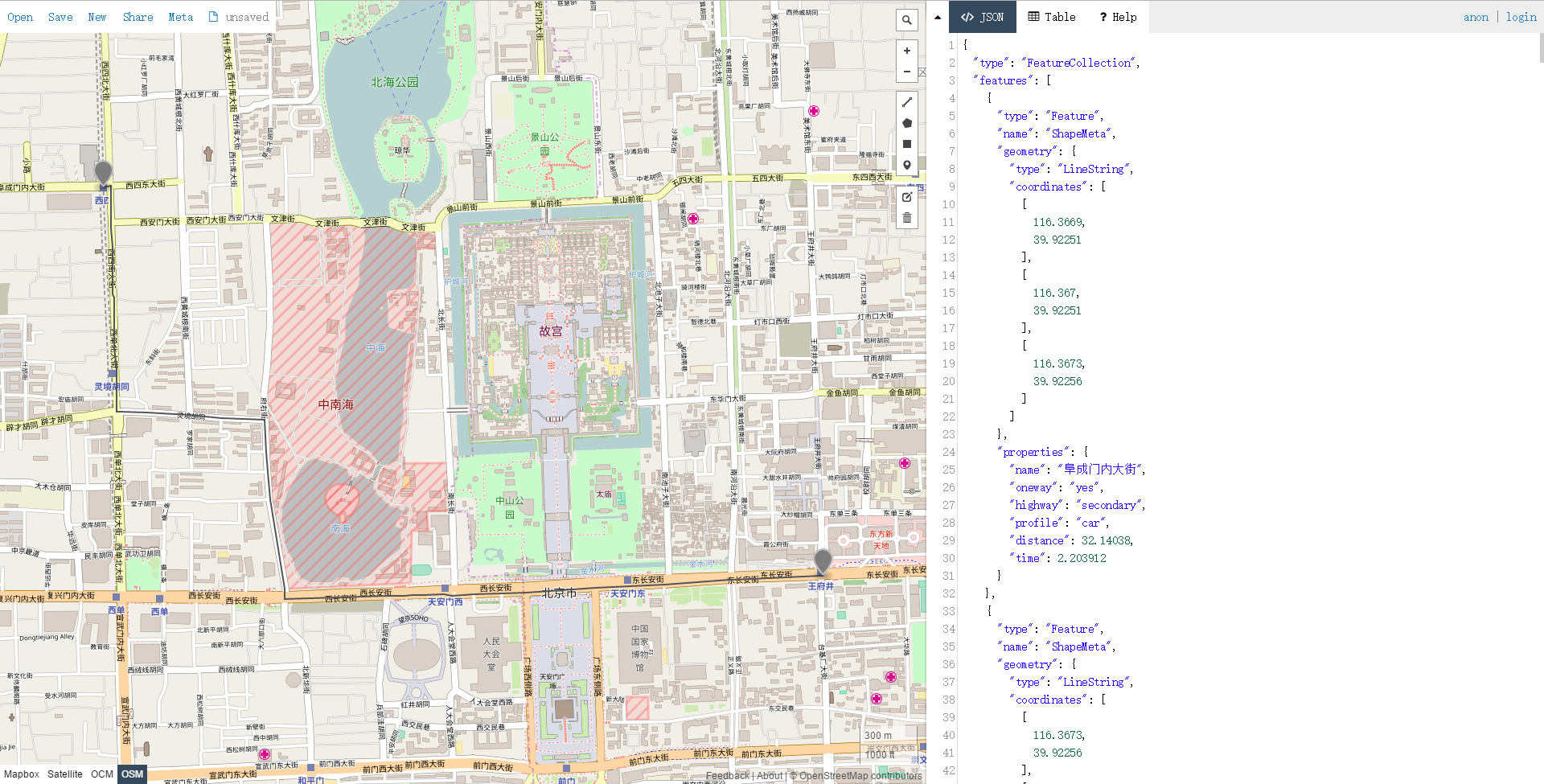
将结果写入GeoJson文件后,添加到geojson.io,计算出的路径如下图。
7.3 实际应用
上述示例对于小区域、城市或国家而言,没什么问题,但是当加载大面积数据时,请使用以下方法。处理原始数据并写入磁盘。
从磁盘加载预处理的数据并将其用于路径规划。
加载原始数据
var routerDb = new RouterDb();
using (var stream = File.OpenRead("beijing.osm.pbf"))
{
routerDb.LoadOsmData(stream, Vehicle.Car);
}
将routerDb实例写入到磁盘:
using (var stream = File.Create("osmfile.routing"))
{
routerDb.Serialize(stream);
}
加载routerDb
using (var stream = File.OpenRead("osmfile.routing"))
{
var routerDb = RouterDb.Deserialize(stream, RouterDbProfile.NoCache);
}
计算
var router = new Router(routerDb);

var profile = Vehicle.Car.Fastest();
var routerPoint1 = router.TryResolve(profile, 39.9225f, 116.3669f);
if(routerPoint1.IsError)
{
// do something or retry.
}
var routerPoint2 = router.TryResolve(profile, 39.9066f, 116.4053f);
if (routerPoint2.IsError)
{
// do something or retry.
}
var route = router.TryCalculate(Vehicle.Car.Fastest(),
routerPoint1.Value, routerPoint2.Value);
if(route.IsError)
{
// do something or retry.
}更过关于路径规划的内容请参考Itinero-GitHub。
更多精彩请关注一氧化二氢
未完待续...

相关文章推荐
- 几种导入osm(openstreetmap)数据的方法
- 如何在GeoServer中使用OpenStreetMap数据
- 使用1角分高程数据为OpenStreetMap服务器添加海洋等深线
- Android OpenStreetMap(OSM) 使用 osmbonuspack 进行导航
- 解析OSM数据(C++ Parser OpenStreetMap Data)
- [原]在GeoServer中为OpenStreetMap数据设置OSM样式
- [旧闻]OpenStreetMap 组织确认苹果正使用他们的地图数据
- Android OpenStreetMap(OSM) 使用 osmbonuspack 进行导航
- 利用OpenStreetMap(OSM)数据搭建一个地图服务
- ArcGIS处理Open Street map数据
- osm 数据格式(openstreet map)与Route --by wangsh
- osm 数据格式(openstreet map)与Route
- 利用OpenStreetMap(OSM)数据搭建一个地图服务
- 使用OpenStreetMap下载kml格式矢量图层数据
- WebGL自学课程(10):通过OpenStreetMap获取数据绘制地球
- VC 2010 下用 TinyXml 解析openstreetmap 地图数据
- 关于OpenStreetMap数据
- OpenStreetMap(OSM) for developers
- OpenStreetMap初探(八)——制作地图瓦片Kosmos及Maperitive使用