IOS之地图和定位应用开发
2013-06-13 16:51
453 查看
11.1 iOS定位服务
11.2 iOS地图
11.3 Web地图
Wifi定位,通过查询一个Wifi路由器的地理位置的信息。比较省电,iPod touch和iPad也可以采用。
蜂窝基站定位,通过移动运用商基站定位。也适合有3G版本的iPod touch和iPad。
GPS卫星定位,通过3-4颗GPS定位位置定位,最为准确,但是耗电量大,不能遮挡。
Core Location
Core Location是iPhone、iPad等开发定位服务应用程序的框架。我们要在Xcode中添加“CoreLocation.framework”存在的框架。
主要使用的类是:CLLocationManager,通过CLLocationManager实现定位服务。
CoreLocation.framework
定位服务实例
项目WhereAmI:
WhereAmIViewController.h
CLLocationManagerDelegate是定位服务的委托,常用的位置变化回调方法是:
locationManager:didUpdateToLocation:fromLocation: locationManager:didFailWithError:
CLLocationManager 是定位服务管理类,通过它可以设置定位服务的参数、获取经纬度等。
m中加载方法
CLLocationManager 是的startUpdatingLocation方法启动所有定位硬件,对应的方法是stopUpdatingLocation,通过调用该方法关闭定位服务器更新,为了省电必须在不用的时候调用该方法关闭定位服务。
此外,我们还可以在这里设定定位服务的参数,包括:distanceFilter和desiredAccuracy。
distanceFilter,这个属性用来控制定位服务更新频率。单位是“米”。 desiredAccuracy,这个属性用来控制定位精度,精度
越高耗电量越大。
定位精度
desiredAccuracy精度参数可以iOS SDK通过常量实现:
kCLLocationAccuracyNearestTenMeters,10米
kCLLocationAccuracyHundredMeters ,100米
kCLLocationAccuracyKilometer ,1000米
kCLLocationAccuracyThreeKilometers,3000米
kCLLocationAccuracyBest ,最好的精度
kCLLocationAccuracyBestForNavigation,导航情况下最好精度,iOS 4 SDK新增加。一般要有外接电源时候才能使用。
委托方法用于实现位置的更新
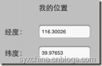
该委托方法不仅可以获得当前位置(newLocation),还可以获得上次的位置(oldLocation ),CLLocation 对象coordinate.latitude属性获得经度,coordinate.longitude属性获得纬度。
[NSString stringWithFormat:@"%3.5f”, newLocation.coordinate.latitude] 中的%3.5f是输出整数部分是3位,小数部分是5位的浮点数。
其核心是MKMapView类使用。
多数情况下地图会与定位服务结合使用。
地图开发一般过程


添加MapKit类库
MapKit.framework
MapMeViewController.h
CLLocationManagerDelegate是定位服务委托。
MKMapViewDelegate是地图视图委托,主要方法:
-mapView:viewForAnnotation:
-mapViewDidFailLoadingMap:withError:
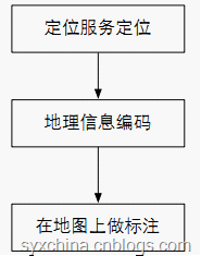
MKReverseGeocoderDelegate是给地理坐标获得标志点信息的委托,用于地理信息编码(即:从坐标获得地点获得信息),主要委托方法:
– reverseGeocoder:didFindPlacemark:
– reverseGeocoder:didFailWithError:
m文件中的视图加载和卸载
mapView.mapType = MKMapTypeStandard;是指定地图的类型,iOS提供了三种风格的地图:
MKMapTypeStandard标准地图模式
MKMapTypeSatellite卫星地图模式
MKMapTypeHybrid具有街道等信息的卫星地图模式
mapView.delegate = self;是将委托对象指定为自身。
按钮事件
点击按钮时候通过定位服务获取当前位置信息。
通过lm.delegate = self;是将委托对象指定为自身。
因此,点击事件发生时候将会回调CLLocationManagerDelegate委托的
-locationManager:didUpdateToLocation:fromLocation:方法。
回调位置更新方法
MKCoordinateRegionMakeWithDistance(newLocation.coordinate, 2000, 2000); 该函数能够创建一个MKCoordinateRegion结构体,第一个参数是一个CLLocationCoordinate2D结构指定了目标区域的中心点,第二个是目标区域南北的跨度单位是米,第三个是目标区域东西的跨度单位是米。后两个参数的调整会影响地图缩放。
[[MKReverseGeocoder alloc] initWithCoordinate:newLocation.coordinate]; 创建地理编码对象geocoder,通过该对象可以把坐标转换成为地理信息的描述。
geocoder.delegate = self;指定编码的处理是自身对象。
[geocoder start];开始编码处理。
MKReverseGeocoderDelegate
是地理编码委托对象,该委托的方法:
成功时候调用-reverseGeocoder:didFindPlacemark:
失败时候调用-reverseGeocoder:didFailWithError:
成功编码回调方法
成功编码后需要在该方法中创建标注对象(MapLocation)。MapLocation 是我们自定义的实现MKAnnotation协议标注对象。 该方法的placemark是MKPlacemark获得很多地理信息,详细见下表。
[mapView addAnnotation:annotation]; 为地图添加标注,该方法将会触发mapView:viewForAnnotation:方法回调。
MKPlacemark类属性
addressDictionary 地址信息的dictionary
thoroughfare 指定街道级别信息
subThoroughfare 指定街道级别的附加信息
locality 指定城市信息
subLocality 指定城市信息附加信息
administrativeArea 行政区域
subAdministrativeArea 行政区域附加信息
country 国家信息
countryCode 国家代号
postalCode 邮政编码
失败编码回调方法
MKMapViewDelegate
是地图视图委托对象,本例子我们使用的方法:
- mapView:viewForAnnotation:为地图设置标注时候回调方法。
-mapViewDidFailLoadingMap:withError:地图加载错误时候回调方法。
地图标注回调方法
与表格视图单元格处理类似,地图标注对象由于会很多,因此需要重复利用,通过
dequeueReusableAnnotationViewWithIdentifier方法可以查找可重复利用的标注对象,以达到节省内存的目的。
annotationView.canShowCallout = YES;指定标注上的插图,点击图钉有气泡显示。
annotationView.pinColor 设置图钉的颜色。
annotationView.animatesDrop动画效果。
地图加载失败回调方法
自定义地图标注对象
作为地图标注对象实现MKAnnotation协议是必须的,只有实现该协议才能使该类成为标注类。实现NSCoding协议是可选的,实现该协议可以使标注对象能够复制。 里面的属性有哪些要看你自己的需要。
MapLocation.m
title 和subtitle 是MKAnnotation协议要求实现的方法。
MapLocation.m
encodeWithCoder:和initWithCoder:是NSCoding协议要求实现方法。

http://maps.google.com/maps?q=Here+I+Am!@%f,%f是请求Web地图的网站,q后面上参数。 [[UIApplication sharedApplication] openURL:url];打开iOS内置的浏览器,即在内置浏览器中打开地图。
11.2 iOS地图
11.3 Web地图
11.1 iOS定位服务
iOS中有三个定位服务组件:Wifi定位,通过查询一个Wifi路由器的地理位置的信息。比较省电,iPod touch和iPad也可以采用。
蜂窝基站定位,通过移动运用商基站定位。也适合有3G版本的iPod touch和iPad。
GPS卫星定位,通过3-4颗GPS定位位置定位,最为准确,但是耗电量大,不能遮挡。
Core Location
Core Location是iPhone、iPad等开发定位服务应用程序的框架。我们要在Xcode中添加“CoreLocation.framework”存在的框架。
主要使用的类是:CLLocationManager,通过CLLocationManager实现定位服务。
CoreLocation.framework
定位服务实例

项目WhereAmI:
WhereAmIViewController.h
#import <UIKit/UIKit.h>
#import <CoreLocation/CoreLocation.h>

@interface ViewController : UIViewController<CLLocationManagerDelegate> {
CLLocationManager* locationManager;
}

@property (strong, nonatomic)    CLLocationManager* locationManager;
@property (retain, nonatomic) IBOutlet UILabel *longitudeText;
@property (retain, nonatomic) IBOutlet UILabel *latituduText;
@property (retain, nonatomic) IBOutlet UIActivityIndicatorView *activity;
- (IBAction)findMe:(id)sender;
- (IBAction)webMap:(id)sender;

@end
CLLocationManagerDelegate是定位服务的委托,常用的位置变化回调方法是:
locationManager:didUpdateToLocation:fromLocation: locationManager:didFailWithError:
CLLocationManager 是定位服务管理类,通过它可以设置定位服务的参数、获取经纬度等。
m中加载方法
- (IBAction)findMe:(id)sender {
self.locationManager = [[[CLLocationManager alloc] init] autorelease];
self.locationManager.delegate = self;
self.locationManager.desiredAccuracy = kCLLocationAccuracyBest;
self.locationManager.distanceFilter = 1000.0f;
[self.locationManager startUpdatingLocation];
[activity startAnimating];
NSLog(@"start gps");
}
CLLocationManager 是的startUpdatingLocation方法启动所有定位硬件,对应的方法是stopUpdatingLocation,通过调用该方法关闭定位服务器更新,为了省电必须在不用的时候调用该方法关闭定位服务。
此外,我们还可以在这里设定定位服务的参数,包括:distanceFilter和desiredAccuracy。
distanceFilter,这个属性用来控制定位服务更新频率。单位是“米”。 desiredAccuracy,这个属性用来控制定位精度,精度
越高耗电量越大。
定位精度
desiredAccuracy精度参数可以iOS SDK通过常量实现:
kCLLocationAccuracyNearestTenMeters,10米
kCLLocationAccuracyHundredMeters ,100米
kCLLocationAccuracyKilometer ,1000米
kCLLocationAccuracyThreeKilometers,3000米
kCLLocationAccuracyBest ,最好的精度
kCLLocationAccuracyBestForNavigation,导航情况下最好精度,iOS 4 SDK新增加。一般要有外接电源时候才能使用。
委托方法用于实现位置的更新
-(void)locationManager:(CLLocationManager *)manager didUpdateToLocation:(CLLocation *)newLocation fromLocation:(CLLocation *)oldLocation {
latituduText.text = [NSString stringWithFormat:@"%3.5f",newLocation.coordinate.latitude];
longitudeText.text = [NSString stringWithFormat:@"%3.5f",newLocation.coordinate.longitude];
[activity stopAnimating];
[locationManager stopUpdatingLocation];
NSLog(@"location ok");
}
该委托方法不仅可以获得当前位置(newLocation),还可以获得上次的位置(oldLocation ),CLLocation 对象coordinate.latitude属性获得经度,coordinate.longitude属性获得纬度。
[NSString stringWithFormat:@"%3.5f”, newLocation.coordinate.latitude] 中的%3.5f是输出整数部分是3位,小数部分是5位的浮点数。
11.2 iOS地图
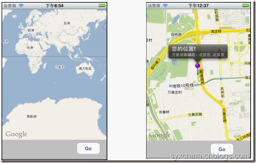
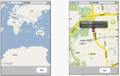
iOS应用程序中使用Map Kit API开发地图应用程序。其核心是MKMapView类使用。
多数情况下地图会与定位服务结合使用。
地图开发一般过程
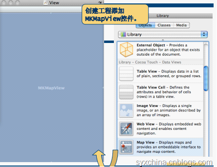
添加MapKit类库
MapKit.framework
MapMeViewController.h
#import <UIKit/UIKit.h>
#import <MapKit/MapKit.h>
#import <CoreLocation/CoreLocation.h>
#import "MapLocation.h"

@interface ViewController : UIViewController<CLLocationManagerDelegate, MKReverseGeocoderDelegate, MKMapViewDelegate> {

}

@property (retain, nonatomic) IBOutlet MKMapView *mapView;
@property (retain, nonatomic) IBOutlet UIActivityIndicatorView *activity;
- (IBAction)findMe:(id)sender;
@end
CLLocationManagerDelegate是定位服务委托。
MKMapViewDelegate是地图视图委托,主要方法:
-mapView:viewForAnnotation:
-mapViewDidFailLoadingMap:withError:
MKReverseGeocoderDelegate是给地理坐标获得标志点信息的委托,用于地理信息编码(即:从坐标获得地点获得信息),主要委托方法:
– reverseGeocoder:didFindPlacemark:
– reverseGeocoder:didFailWithError:
m文件中的视图加载和卸载
- (void)viewDidLoad {
[super viewDidLoad];
mapView.mapType = MKMapTypeStandard;
//mapView.mapType = MKMapTypeSatellite;
//mapView.mapType = MKMapTypeHybrid;
mapView.delegate = self;
}
mapView.mapType = MKMapTypeStandard;是指定地图的类型,iOS提供了三种风格的地图:
MKMapTypeStandard标准地图模式
MKMapTypeSatellite卫星地图模式
MKMapTypeHybrid具有街道等信息的卫星地图模式
mapView.delegate = self;是将委托对象指定为自身。
按钮事件
- (IBAction)findMe:(id)sender {
CLLocationManager *lm = [[CLLocationManager alloc] init];
lm.delegate = self;
lm.desiredAccuracy = kCLLocationAccuracyBest;
[lm startUpdatingLocation];

activity.hidden = NO;
[activity startAnimating];
}
点击按钮时候通过定位服务获取当前位置信息。
通过lm.delegate = self;是将委托对象指定为自身。
因此,点击事件发生时候将会回调CLLocationManagerDelegate委托的
-locationManager:didUpdateToLocation:fromLocation:方法。
回调位置更新方法
#pragma mark CLLocationManagerDelegate Methods
- (void)locationManager:(CLLocationManager *)manager
didUpdateToLocation:(CLLocation *)newLocation
fromLocation:(CLLocation *)oldLocation {

MKCoordinateRegion viewRegion = MKCoordinateRegionMakeWithDistance(newLocation.coordinate, 2000, 2000);
//[mapView setRegion:viewRegion animated:YES];
MKCoordinateRegion adjustedRegion = [mapView regionThatFits:viewRegion];
[mapView setRegion:adjustedRegion animated:YES];

manager.delegate = nil;
[manager stopUpdatingLocation];

MKReverseGeocoder *geocoder = [[MKReverseGeocoder alloc] initWithCoordinate:newLocation.coordinate];
geocoder.delegate = self;
[geocoder start];
}
MKCoordinateRegionMakeWithDistance(newLocation.coordinate, 2000, 2000); 该函数能够创建一个MKCoordinateRegion结构体,第一个参数是一个CLLocationCoordinate2D结构指定了目标区域的中心点,第二个是目标区域南北的跨度单位是米,第三个是目标区域东西的跨度单位是米。后两个参数的调整会影响地图缩放。
[[MKReverseGeocoder alloc] initWithCoordinate:newLocation.coordinate]; 创建地理编码对象geocoder,通过该对象可以把坐标转换成为地理信息的描述。
geocoder.delegate = self;指定编码的处理是自身对象。
[geocoder start];开始编码处理。
MKReverseGeocoderDelegate
是地理编码委托对象,该委托的方法:
成功时候调用-reverseGeocoder:didFindPlacemark:
失败时候调用-reverseGeocoder:didFailWithError:
成功编码回调方法
- (void)reverseGeocoder:(MKReverseGeocoder *)geocoder didFindPlacemark:(MKPlacemark *)placemark {

MapLocation *annotation = [[MapLocation alloc] init];
annotation.streetAddress = placemark.thoroughfare;
annotation.city = placemark.locality;
annotation.state = placemark.administrativeArea;
annotation.zip = placemark.postalCode;
annotation.coordinate = geocoder.coordinate;
[mapView addAnnotation:annotation];

[annotation release];
geocoder.delegate = nil;
[geocoder autorelease];

[activity stopAnimating];
activity.hidden = YES;
}
成功编码后需要在该方法中创建标注对象(MapLocation)。MapLocation 是我们自定义的实现MKAnnotation协议标注对象。 该方法的placemark是MKPlacemark获得很多地理信息,详细见下表。
[mapView addAnnotation:annotation]; 为地图添加标注,该方法将会触发mapView:viewForAnnotation:方法回调。
MKPlacemark类属性
addressDictionary 地址信息的dictionary
thoroughfare 指定街道级别信息
subThoroughfare 指定街道级别的附加信息
locality 指定城市信息
subLocality 指定城市信息附加信息
administrativeArea 行政区域
subAdministrativeArea 行政区域附加信息
country 国家信息
countryCode 国家代号
postalCode 邮政编码
失败编码回调方法
- (void)reverseGeocoder:(MKReverseGeocoder *)geocoder didFailWithError:(NSError *)error {
UIAlertView *alert = [[UIAlertView alloc]
initWithTitle:@"地理解码错误息"
message:@"地理代码不能识别"
delegate:nil
cancelButtonTitle:@"Ok"
otherButtonTitles:nil];
[alert show];
[alert release];

geocoder.delegate = nil;
[geocoder autorelease];

[activity stopAnimating];
}
MKMapViewDelegate
是地图视图委托对象,本例子我们使用的方法:
- mapView:viewForAnnotation:为地图设置标注时候回调方法。
-mapViewDidFailLoadingMap:withError:地图加载错误时候回调方法。
地图标注回调方法
#pragma mark Map View Delegate Methods
- (MKAnnotationView *) mapView:(MKMapView *)theMapView viewForAnnotation:(id <MKAnnotation>) annotation {

MKPinAnnotationView *annotationView = (MKPinAnnotationView *)[mapView dequeueReusableAnnotationViewWithIdentifier:@"PIN_ANNOTATION"];
if(annotationView == nil) {
annotationView = [[[MKPinAnnotationView alloc] initWithAnnotation:annotation
reuseIdentifier:@"PIN_ANNOTATION"] autorelease];
}
annotationView.canShowCallout = YES;
annotationView.pinColor = MKPinAnnotationColorRed;
annotationView.animatesDrop = YES;
annotationView.highlighted = YES;
annotationView.draggable = YES;
return annotationView;
}
与表格视图单元格处理类似,地图标注对象由于会很多,因此需要重复利用,通过
dequeueReusableAnnotationViewWithIdentifier方法可以查找可重复利用的标注对象,以达到节省内存的目的。
annotationView.canShowCallout = YES;指定标注上的插图,点击图钉有气泡显示。
annotationView.pinColor 设置图钉的颜色。
annotationView.animatesDrop动画效果。
地图加载失败回调方法
- (void)mapViewDidFailLoadingMap:(MKMapView *)theMapView withError:(NSError *)error {
UIAlertView *alert = [[UIAlertView alloc]
initWithTitle:@"地图加载错误"
message:[error localizedDescription]
delegate:nil
cancelButtonTitle:@"Ok"
otherButtonTitles:nil];
[alert show];
[alert release];
}
自定义地图标注对象
#import <Foundation/Foundation.h>
#import <MapKit/MapKit.h>

@interface MapLocation : NSObject <MKAnnotation, NSCoding> {
NSString *streetAddress;
NSString *city;
NSString *state;
NSString *zip;

CLLocationCoordinate2D coordinate;
}
@property (nonatomic, copy) NSString *streetAddress;
@property (nonatomic, copy) NSString *city;
@property (nonatomic, copy) NSString *state;
@property (nonatomic, copy) NSString *zip;
@property (nonatomic, readwrite) CLLocationCoordinate2D coordinate;
@end
作为地图标注对象实现MKAnnotation协议是必须的,只有实现该协议才能使该类成为标注类。实现NSCoding协议是可选的,实现该协议可以使标注对象能够复制。 里面的属性有哪些要看你自己的需要。
MapLocation.m
- (NSString *)title {
return @"您的位置!";
}
- (NSString *)subtitle {

NSMutableString *ret = [NSMutableString string];
if (streetAddress)
[ret appendString:streetAddress];
if (streetAddress && (city || state || zip))
[ret appendString:@" • "];
if (city)
[ret appendString:city];
if (city && state)
[ret appendString:@", "];
if (state)
[ret appendString:state];
if (zip)
[ret appendFormat:@", %@", zip];

return ret;
}
title 和subtitle 是MKAnnotation协议要求实现的方法。
MapLocation.m
#pragma mark -
- (void)dealloc {
[streetAddress release];
[city release];
[state release];
[zip release];
[super dealloc];
}
#pragma mark -
#pragma mark NSCoding Methods
- (void) encodeWithCoder: (NSCoder *)encoder {
[encoder encodeObject: [self streetAddress] forKey: @"streetAddress"];
[encoder encodeObject: [self city] forKey: @"city"];
[encoder encodeObject: [self state] forKey: @"state"];
[encoder encodeObject: [self zip] forKey: @"zip"];
}
- (id) initWithCoder: (NSCoder *)decoder  {
if (self = [super init]) {
[self setStreetAddress: [decoder decodeObjectForKey: @"streetAddress"]];
[self setCity: [decoder decodeObjectForKey: @"city"]];
[self setState: [decoder decodeObjectForKey: @"state"]];
[self setZip: [decoder decodeObjectForKey: @"zip"]];
}
return self;
}
encodeWithCoder:和initWithCoder:是NSCoding协议要求实现方法。
11.3 Web地图
在iOS中我们还可以使用Web地图。
- (IBAction)webMap:(id)sender {
CLLocation *lastLocation = [locationManager location];
if(!lastLocation)
{
UIAlertView *alert;
alert = [[UIAlertView alloc]
initWithTitle:@"系统错误"
message:@"还没有接收到数据!"
delegate:nil cancelButtonTitle:nil
otherButtonTitles:@"OK", nil];

[alert show];
[alert release];
return;
}

NSString *urlString = [NSString stringWithFormat:
@"http://maps.google.com/maps?q=Here+I+Am!@%f,%f",
lastLocation.coordinate.latitude,
lastLocation.coordinate.longitude];
NSURL *url = [NSURL URLWithString:urlString];

[[UIApplication sharedApplication] openURL:url];
}
http://maps.google.com/maps?q=Here+I+Am!@%f,%f是请求Web地图的网站,q后面上参数。 [[UIApplication sharedApplication] openURL:url];打开iOS内置的浏览器,即在内置浏览器中打开地图。

相关文章推荐
- IOS之地图和定位应用开发
- IOS之地图和定位应用开发
- IOS之地图和定位应用开发
- iOS之地图和定位应用开发
- 判断一个坐标点是否在一个无规则的多边形内 (iOS定位服务与地图应用开发:高德地图开发)
- iOS学习笔记–11 IOS之地图和定位应用开发
- IOS之地图和定位应用开发
- iOS开发地图应用,模拟器不询问我是否能获得定位权限
- IOS之地图和定位应用开发
- iOS开发之地图和定位应用开发
- IOS之地图和定位应用开发
- IOS之地图和定位应用开发
- IOS之地图和定位应用开发
- 11.3 IOS之地图和定位应用开发
- IOS之地图和定位应用开发
- IOS之地图和定位应用开发
- IOS之地图和定位应用开发
- IOS之地图和定位应用开发
- iOS地图和定位的应用开发
- IOS之地图和定位应用开发